
History and heritage
Geology
The Dee Estuary was created during the last Ice Age, approximately 22,000 years ago during a period known as the Late Devensian or Last Glacial Period. Devensian is derived from the Latin, Dēvenses, meaning people living by the Dee (Dēva in Latin), a river in the Northwest UK that forms part of the border between England and Wales and is the major tributary of fresh water into the Dee Estuary.
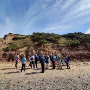
The best place to see this geological history is the Thurstaston Cliffs, at Wirral Country Park.
Here you can see the different layers that were deposited as the glacier moved through the landscape. These layers are known as till and are laid down within the liquid water, or melt, that runs below the solid ice of the glacier.
Within the till are a variety of stones and pebbles that were collected by the glacier as it moved through the landscape from its source in the Irish Sea, through the Lake District, to the Wirral.
The glacial erratic’s, the large boulders displayed near the Visitors Centre at Wirral Country Park, came out of the Thurstaston Cliffs, and are thought to have come from as far as the Irish Sea, Scotland and the Lake District.
There is evidence to suggest that the estuary has been silting up from as early as the 11th century due to the huge quantities of sandy glacial material being brought in by the tidal flow from Liverpool Bay and not being flushed out again due to the shape of the estuary.
Life on the Dee Estuary
Canalisation of the River Dee
The Dee Estuary has undergone much change, particularly over the last 300 years and you can see evidence of these changes if you know where to look.
Pictures lining the walls of The Boathouse pub at Parkgate show a bustling port where shrimp and bananas were traded. At low tide there was also a wide sandy beach for holidaymakers and residents alike to enjoy.
Travelling further back in time Burton has evidence of a medieval hospital for “the poor and shipwrecked”.
In Neston by the Harp Inn are the remains of Denhall Quay and in Shotwick there is an iron mooring ring attached to the door of St Michael’s Church.
Written evidence indicates that by 1449 the estuary was becoming difficult to navigate due to siltation and that the port of Chester was no longer easily accessible for larger vessels. The city established a series of outports at Shotwick, Denhall Quay and Parkgate where the larger vessels could offload their cargo onto smaller vessels.
Fast forward to 1647 and a ‘New Cut’ within the estuary between Chester and Flint was proposed and an Act of Parliament was passed in 1700 permitting the City of Chester to recover and maintain the navigation of the river Dee.
After a failed attempt in 1707 the ‘New Cut’ was finally completed in 1737 by removing 1.5 million tons of earth wholly by man and horsepower to form the north bank of the new cut and this is the water course we know today.
Tourism
Crossing the Dee Estuary
There has always been a need for people to cross the Dee Estuary. Today we are familiar with road crossings at Connah’s Quay, Queensferry and Chester, but they have not always been there. There are accounts from the early 1700s of guided foot crossings used particularly by salt traders. The route involved following the tideline from Flint to a point between Kelsterton and Golftyn. From there the crossing would be made heading towards the Greyhound Inn at Shotwick. The route could not always be the same because the sand and mud would shift with successive tides.
Following the passing of the Dee Navigation Act in 1732, two ferry crossings were established in 1737. The Higher Ferry at Saltney was for passengers and the Lower Ferry at what is now Queensferry took vehicles and animals. There is some suggestion that there was an earlier service between Flint and Parkgate but the Higher and Lower Ferries were the major crossings. More can be found about the Higher Saltney Ferry by following this link to Saltney ferryman’s past revived in new trail.
There are also a number of accounts of accidents and disasters relating to Ferry Crossing that can be found by following this link to research by Liverpool University into wrecks of various kinds on the Dee Estuary.
Wrecks in the Dee Estuary by Chris Michael.
Later there were also smaller services between Parkgate and Bagillt in 1817 and between Gayton and Greenfield in 1819 but by the middle of the 19th Century all the ferries were in decline because of the rise of the railway crossings like the one at Overton built in 1840.
The Lower Ferry at Saltney survived until 1968 when it was replaced by a footbridge.
RNLI
Today, Lifeboat services for the Dee Estuary are provided by the RNLI stations at Flint, Rhyl and Hoylake, but this has not always been the case. From 1826, and possibly earlier, until 1923 there was a lifeboat located at Point of Ayr. Nothing remains of the station today, but its position was included on the Ordnance Survey Map of 1898. The station was established by the Liverpool Docks Trust and taken over by the RNLI in 1894. Over the years the volunteers manning the boat saved hundreds of lives. In 1868 alone, according to records at Liverpool University the lifeboat was called out no fewer than seven times.
The most famous, or infamous, action by the lifeboat occurred in January 1857 when the boat was lost along with 13 crewmen when they were attempting to come to the aid of the schooner, Temperance, which was reported by the Foelnant Telegraphy station as having run aground off Abergele. A more detailed account of the tragedy can be found on the Curious Clwyd website in the article – The Temperance and a memorial to those lost can be found at the Church of St Asaph and St Cynderyn in Llanasa where the bodies that were recovered were buried.
Curiously, The Point of Ayr lifeboat was not the only one to operate on the Dee Estuary in the 1800s. In 1835 the townspeople of Mostyn decided that they wanted a lifeboat of their own. It only lasted until 1850 having only once been called out in 1839 and so proving superfluous given the service provided by its more illustrious neighbour.
Seaside resorts on the Dee Estuary
Talacre and Point of Ayr
Talacre and Point of Ayr is a great place to visit whether you are just there for the day or your planning a long weekend or school holiday getaway.
Talacre has a rich history as a seaside resort, dating back to the 1930’s when the first chalets were built on The Warren. The site was then dominated by wartime activities mainly from the RAF between 1938 ad 1945. Tourists start returning in 1945 and by 1960 the caravan parks had started to develop. By the mid 1970’s the chalets had all been cleared leaving caravan parks as the primary source of accommodation for visitors.
If you would like to know more about the history of Talacre we recommend Talacre Memories, a booklet produced by Flintshire Countryside and Coast as part of the Talacre Then and Now project.
Flint
Flint is a great place to set off on a walk along the Wales Coast Path as it has plenty of parking and great public transport links You can either go east towards Chester or you can go west towards Greenfield.
A great walk all year round is Flint Castle to Basingwerk Abbey, a 6 mile or 10km walk taking in the Dee Estuary and two historically important sites.
Parkgate
Parkgate was once a bustling port however now only the highest of Spring tides reaches the sea wall that runs along the main street.
When the ‘new cut’ was created in the Dee Estuary this drastically changed how the sediment moved in the estuary and Parkgate quickly silted up which led to the development of saltmarsh and reedbed habitat which is now a haven for small mammals and birds alike.
Parkgate is still famous for its fish and chips and ice cream but is it no longer the seaside resort it once was. Instead it is a mecca for bird watchers who flock to see the short eared owls and marsh harrier that come to hunt among the reedbed and saltmarsh.
Hoylake
Hoylake has a long and varied history as a coastal destination in the northwest of England. It is named after Hoyle Bank, an extensive sand bank that extends out of Hilbre Island and is regularly used by a colony of seals to haul out after a big day’s fishing.
West Kirby
West Kirby has both a beach and a marine lake allowing people to participate in a variety of activities such as sailing and kayaking. Thousands of people walk around the marine lake every year but do make sure you check the tide times as the marine lake is refreshed by the tide twice a day and the footpath soon disappears under the water.
The marine lake was built in 1899 and then the wall was breached in 1985. It was rebuilt in 1987 which expanded the marine lake, doubling its width.
Industry
The leather industry in Chester
It will surprise many people to find that the primary industry in medieval Chester was leather.
As well as a large number of tanneries there were also many leather workers making saddles, shoes, and gloves. Some skins would be obtained from local farms, but the majority were shipped in up the Dee Estuary from Ireland. The skins used varied from the more expected cattle and sheep hides through to martens, foxes and even badgers and otters. The finished products were transported back along the estuary and then further afield to London and to Continental Europe.
There are still clues to the city’s history of leather working for example placenames like Shoemaker’s Row, the Gloverstone at the Castle and the curious gloved wooden hand that hangs in Eastgate Street marking the location of the now lost Crown and Glove Hotel.
More about the history of Chester’s leather working and how the Estuary played a significant part in it can be found by following the links below.
Industrial Revolution – Chesterwiki
British History Online – Later medieval Chester 1230-1550: Economy and society, 1350-1550
British History Online – Early modern Chester 1550-1762: Economy and society, 1662-1762
Lead Mining in Pre-1700 Flintshire
Since Roman times, and possibly earlier, lead has been mined in Flintshire and on Halkyn Mountain in particular. The intensity of the mining has fluctuated over time depending on the balance between demand for lead and the cost of the extraction.
The tools used to dig out the soft, malleable ore remained unchanged for centuries as shovels, pickaxes, crowbars and hammers were used to work the veins that were frequently visible on the surface. Often, before the advent of professional miners, this would be done by farmers looking to supplement their income. The ore would then be transported to a centralised site of smelting, like Holywell using wooden buckets, wheelbarrows or sledges depending on the terrain. As far back as 1520 it was recognised by the locals that lead processing was poisonous and there are reports of smelting works being destroyed. As the digging went deeper, shafts were created and shored up, but flooding was an ever present danger and led to shafts being capped off and abandoned.
Demand for lead increased greatly in the 1200s when there was a major castle building program following the defeat of the Welsh Princes. There was a further increase in the 1600s when new technologies for pumping out water and for using gunpowder to blast made mining more profitable for investors.
More information can be found by following these links:
The Industrial Revolution in North Wales – Greenfield Valley Heritage Park
Flintshire Lead Mining – Cambrian Mines Trust
Lead smelting in Bagillt
About 1 km inland from Bagillt is Gadlys and during the 1700s this was the location of one of the most important sites of the Industrial Revolution.
Ever since Roman times, lead mines in Flintshire had been worked and the lead smelted and transported via the Estuary. Around 1700 there was a huge increase in activity because of the demands for lead from other growing industries and this culminated in the opening of the Gadlys smelting works in 1704 by the London Lead Company.
Over the following decades large quantities of lead were mined from many locations around Flintshire, particularly Halkyn Mountain, and brought to Gadlys for processing. In the 1720s Gadlys was being recognised as a major contributor to the expansion of heavy industry across the UK. But there were also signs of the problems ahead.
Water in the mines was becoming a major problem and it became increasingly difficult to extract the ore in sufficient quantities from the local mines. By the mid 1730s there were several initiatives started to try and maintain the profitability of the operation but to no avail. By 1779 the site at Gadlys was in serious decline and all operations were ceased by 1799.
Little remains now of what was once a thriving industry, nonetheless Gadlys and Bagillt were once at the heart of the Industrial Revolution and the United Kingdom’s prosperity.
A more detailed history of lead processing in Flintshire can be found by following this link:
The Gladlys Smelting Works – Curious Clwyd
Shipbuilding
As late as 1935 the Dee Estuary was the home to several shipyards although there are none now.
One of the best documented was the Sandycroft Foundry and Ironworks. Once having a reputation for innovation under the ownership of a Mr Rigby, it was taken over by George Cram in 1853 but was wound up in 1856. More details can be found by following this link:
Sandycroft Foundry and Ironworks 1853 – Casgliad y Werin Cymru / People’s Collection Wales
At Saltney and later Connah’s Quay, J. Crichton and Company was active between 1913-1935 building a wide variety of vessels including Barges, Coaster and even Lightships.
Grace’s Guide to British Industrial History – J. Crichton and Co.
Between 1814 and 1931 Chester was also a centre of ship and boat building at the Roodee, most notably perhaps Courtneys which suffered a major fire in 1817. Details of the history of shipbuilding in Chester, along with several other fascinating items can be found by following this link.
Meanwhile at Queensferry Abdela & Mitchell were building boats between 1900 and 1931. It was said that they built The African Queen used in the film with Humphrey Bogart and Katherine Hepburn but sadly this has been refuted.
Grace’s Guide to British Industrial History – Abdela, Mitchell and Co.
The most widely known ship to be built on the Estuary though is probably the Kathleen and May built by Ferguson and Baird in 1900. It used to be a familiar sight on UK television screens as it featured in the long running BBC maritime drama The Onedin Line.
History Points – Site of ‘Kathleen & May’ shipyard, Connah’s Quay
Archaeology
It’s no surprise that with Chester being the point at which the river Dee meets the Irish Sea there is a rich archaeological history in the area from the Romans to the present day.
If you would like to know more about the archaeology of the Dee Estuary then there are plenty of sources of information for you to explore.
Chester hold a Heritage Festival every year but you can also use many of their resources and visit many of the places featured all year round and they also have a special feature on Archaeology in the area.
Wirral Archaeology is a volunteer run group that is investigating multiple sites around the Wirral peninsula for their archaeological history.
Council for British Archaeology, that run the Festival of Archaeology in July each year, have many events on throughout the year and run the Young Archaeologists Clubs or YACS of which there is one right here on the Dee.


